
-
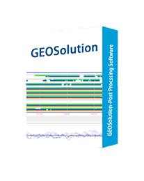
GEOSolution
SIMPLE & INDISPENSABLE POST PROCESSING SOFTWARE
Simple and powerful post-processing software, owning many preset coordinate systems and advanced data processing algorithms to process static data and obtain reliable results quickly.
-
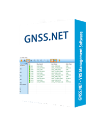
GNSS.NET
WINDOWS – VRS MANAGEMENT SOFTWARE
GNSS.NET is the software to combine multiple base stations as a network providing VRS service. It includes functions such as station management, user management, physical base station data transmission, VRS service, coordinate system transmission…
-
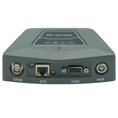
NET10
GNSS REFERENCE STATION RECEIVER
The eSurvey NET10 is specially designed for a user who needs to set up reference stations. With the 3D choke-ring antenna, the device provides stable correction data to the rover. Integrated with Bluetooth, WIFI, Web UI, ethernet, and serial port, NET10 brings the possibility for more applications.
-
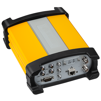
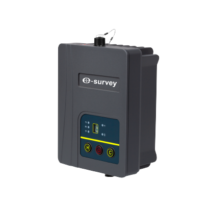
NET20 PLUS
HIGH-PERFORMANCE GNSS REFERENCE STATION RECEIVER
The eSurvey NET20 PLUS is designed for high-precision CORS reference stations. With a 13600 mAh battery that can ensure continuous recording and respond to the emergency. Users can use any phone or tablet to configure devices easily from the powerful Web UI. The rich data interface demands various applications such as monitoring and machine control.
-
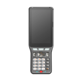
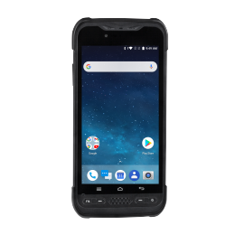
P9IV
A PROFESSIONAL RUGGED CONTROLLER FOR ANY APPLICATIONS
The eSurvey P9IV is a professional-grade Android 11 controller, designed for long time fieldwork. With IP67 certified, the P9IV is suitable for any tough environments. With its ergonomic design, the P9IV offers easy one-handed use and provides extended flexibility during fieldwork. Featuring a MTK 8-core 2.0 GHz processor, Bluetooth 5.0, and a 5.0 inch HD touchscreen, the P9IV provides excellent performance and smooth experience either in or outside the field.
-
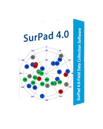
Surpad4.2
ANDROID – FIELD DATA COLLECTION SOFTWARE
Powerful Functions Enjoy the powerful functions, including tilt survey, CAD, line stakeout, road stakeout, GIS data collection, COGO calculation, QR code scanning, FTP transmission, etc. Abundant Formats for Importing and Exporting Directly import and export files with frequently used formats and customized formats. Easy-to-use UI Freely choose the desired display style, including list, grid, and customized style, and enjoy easy operations with graphic interaction, including COGO calculation, QR code scanning, FTP transmission, etc. Advanced Display of Base Maps Supports the import of different formats of base maps including, but not limited to AutoCAD formats (DXF, DWG), SHP and Land XML, which provides a more user-friendly experience during fieldwork. Compatible with Any Android Devices Use it on all Android devices (Android 7.0 and above), including eSurvey handhelds, Android phones, tablets, and other third-party Android devices. Powerful CAD Function

-
TRU35
ADVANCED & RUGGED EXTERNAL RADIO FOR A LONG-DISTANCE TRANSMISSION
The eSurvey TRU35 is a high-power, small-size, half-duplex digital radio model, which is designed using advanced 32-bit cortex M4 micro-controller technology, wireless transceiver RF technology, and digital communication technology. It uses high-quality RF components, excellent EMC and EMI processing.
-
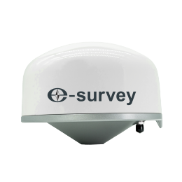
UA35
GNSS ANTENNA
The eSurvey UA35 covers the reception of GNSS signals such as GPS, GLONASS, BDS, Galileo, QZSS, IRNSS and L-Band. It has the superior performance of the antenna phase center. Its small size and light weight make it easy to carry around and operate.
-
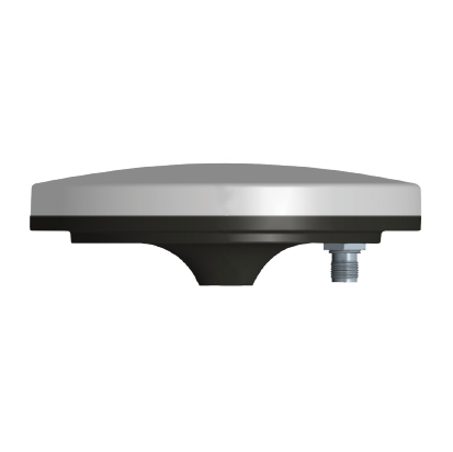
UA91
CHOKE RING ANTENNA
The eSurvey UA91 adopts a high-gain broadband antenna to receive GNSS signals such as GPS, BDS, GLONASS, Galileo, IRNSS, QZSS, and L-Band. The scheme of multi-stage 3D choke coils with a symmetrical distribution is adopted to achieve higher phase center stability and excellent anti-multipath interference performance. It has excellent performance and the phase center coincides with the mechanical center.
-
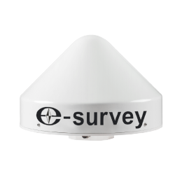
UA92
HIGH-GAIN CHOKE RING ANTENNA
The eSurvey UA92 is a multi-system full-frequency reference station antenna covering BDS, GPS, GLONASS, IRNSS, QZSS and GALILEO. It adopts a unique choke structure design. The product has a stable phase center, good multipath suppression effect, high positioning accuracy, and low elevation angle reception.
-
UT12P
6” Rugged Android Handheld
All field operations must be conducted with the right devices to solve problems and extend the mobility of workers. In an increasingly digital world, productivity is closely linked to the quality of the equipment deployed. The UT12P looks great as a rugged smartphone and certified IP68 along with MIL-STD-810G can be used as both a smartphone and a handy tool in rustic working conditions minimizing the risk of damage, the cost of repairs and downtime your work.
-
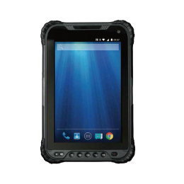
UT32
8” Rugged Android Tablet
The UT32 is an 8-inch tablet with Full HD resolution (1280 x 800 pixels). The screen is also bright and colorful, making it easier for you to work. As far as internal performance goes, this is an excellently fast tablet; you can expect plenty of speed and fewer frozen apps thanks to the tablet’s 2.2GHz octa-core processor. Thanks to its impressive 8200 mAh rechargeable battery, the device can operate for 6 hours on a single charge. The UT32 is a superb rugged tablet option for anyone looking for portable, easy-to-use tablets.
-
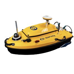
VE115
UNMANNED SURFACE VESSEL SOLUTION
The eSurvey VE115 is a full-integrated innovative solution for 3D bathymetric surveys and is widely used for different types of research including hydrology, leakage, water-quality studies, the contour of streams and reservoirs, storage and fill-in reservoirs and ponds, etc. The VE115 carries up to 15 kg of payload and is completely autonomous, it is safely operated from the shore. The VE115 offers an unmanned operation solution with a shallow draft, high navigational accuracy, and stable hovering for hydrologists.
-
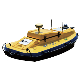
VE158
A MULTI-PURPOSE SURVEYING UNMANNED SURFACE VESSEL
Introducing the eSurvey VE158, a groundbreaking and fully integrated solution designed specifically for 3D bathymetric surveys. This innovative system has gained widespread recognition across a range of studies, including hydrology, seepage analysis, water quality studies, profiling streams and reservoirs, and managing reservoir and pond impoundment. The eSurvey VE158 boasts a meticulously engineered hull with a comprehensive sealing design. To ensure maximum protection, anti-collision strips have been strategically installed around the hull, providing resistance against sinking and corrosion. The body design is optimized for space efficiency, featuring a modular structure that is lightweight yet capable of carrying substantial loads.